Britannica Dictionary definition of ART. 1. [noncount] : something that is created with imagination and skill and that is beautiful or that expresses important ideas or feelings.
Bencher: An individual who takes photographs of graffiti. The term originated in New York when the graffiti writers and non-graffiti writers would sit on benches at train stations waiting for the trains to go by to take pictures and admire graffiti.Glossary of graffiti from Wikipedia.
Putting aside the question of What is Art and who gets to define it? for a while, something has been happening to blank city walls almost everywhere. I don’t mean graffiti-like Summer in the Granary, below, which is from a different tradition; I mean much more traditional painting, possibly commissioned and probably with an actual permit. I saw my first exterior wall painting – for lack of a better descriptor – in 1976, in Palo Alto, of all places. There were several – eventually, nine – approximately life-size figures painted on walls around town. Two I remember were an alien in a flying saucer crashed into a bank wall and two burglars escaping down the side of a building. This was before Silicon Valley was Silicon Valley and the figures seemed cute and wholesome.
Except for that, I don’t really remember any street art until I was driving by some wall paintings on 6th Street in San Francisco. They had already been defaced but I was instantly attracted – for lack of a better word – to it. Now I see wall art everywhere. Well, maybe not everywhere but almost everywhere, all over Paris, even Elko Nevada. Salt Lake City is full of Street Art and proud of it. Especially in the Granary District where we were staying, all we had to do is walk out the front door and wander the long way through the neighborhood on our way to getting coffee.
We ended our wall painting walk trying to guess the various luminaries at the SLC Pepper wall painting (with life-size figures). This remake by Jan Haworth, who collaborated on the original Beatles’ Sgt Pepper cover, features a lot more women and people of color. It was paid for by Zions Bank for us to enjoy.
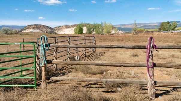
When we were in Salt Lake City, we stayed at the evo Hotel, which advertised itself as a new kind of gathering place for our community….a laid-back hotel with a rooftop bar. When we first checked in, I thought, This is so cool; we are sooo with it. The hotel shares what were formally five brick warehouses, with a climbing gym – that was free to hotel guests – and two evo stores that offer roughly the same kind of clothes and equipment as REI.
The hotel is about 35 minutes from the lifts at Part City and is designed as a place to stay during the ski season without being an actual resort. We were there during slack season, so the hotel was pretty empty, and it would probably feel different if it was full of skiers. The basic philosophy seems to be having smaller rooms with more public space, like the room above, overlooking one of several climbing walls and the “rooftop bar” that overlooks the street. Our room was small and didn’t have a window, a desk, or reliable WiFi. That would have been OK – not ideal, but OK – except that the public desks did not have reliable WiFi either.
The hotel is in a rundown warehouse area that was rapidly gentrifying. Very rapidly.
Not having good WiFi – good being defined as reliable – is worse in an empty hotel with rooms without windows. The empty part was a problem with the Natural History Museum and The City Library. The enormous Lobby of the Natural History Museum, which, according to Ennead, was inspired by Utah’s distinctive slot canyons, a dramatic central public space…organizes the visitor experience….and uplifts and inspires. The problem was that the space was empty. That’s great in a slot canyon but, even in a very busy building, gives a feeling of disuse and neglect (a little like looking into an empty conference room in a busy hotel).
The Library’s Lobby and Plaza, which, according to Safdie Architects, is an “urban room,” a public space open through the waking hours, [which] attracts every facet of Salt Lake City’s community, was also virtually empty except for a couple of homeless people (from now on called “unhoused” people). It gave the place a slightly creepy feeling. I want to point out that the Safdie website shows both of these area being well used and they probably are on a warm Sunday afternoon.
These empty spaces alone with Salt Lake City’s extra wide streets and new construction, don’t so much give the impression of abandonment as the party quite hasn’t started yet.
Salt Lake City surprised and sometimes delighted us. It was unexpectedly interesting. Salt Lake was founded by Brigham Young and the Mormons who were following him. Those early believers laid the streets out on a rigid north-south grid- just like Escalante, only way bigger – and they have to be wide enough to turn an ox-drawn wagon around, both of which contribute to a slightly different feel than, say, San Jose. Salt Lake is both grubbier than I expected, with lots of homeless people, and booming, with the construction of new apartments almost everywhere.
As an aside, I wonder if a booming local economy and homelessness are connected. I hope not. End aside.
Salt Lake also feels more Liberal than I expected, with a woman mayor – the city’s third woman mayor, BTW – although on thinking about it, the Liberalism might be an illusion. I think it feels more Liberal to me because I associate Liberal with concern for the greater Community, as opposed to living in a gated community, and Salt Lake City’s many new public buildings and parks exude Liberal Civic Pride.
In the foothills of the Wasatch Mountains, almost due east from downtown – and I’m defining downtown as Temple Square – is the Natural History Museum of Utah overlooking Salt Lake City like the Lawrence Hall of Science over Berkeley and the Bay. I’ve read, and Linda Melton has reminded me that the tallest buildings in a village or a town or – even/especially, take your pick – a cosmopolitan city reflect the place’s values. In that way, this building which is high on a hill overlooking Salt Lake is a statement building saying Science is valued here, which somehow warms my soul.
The Museum is designed by Ennead – that’s all, Ennead, just Ennead – who have offices in both New York and Shanghai and seem to be a sort of a co-op specializing in museum and public buildings. They have designed a 427,000 square-foot natural history museum for the Yangtze River Estuary Chinese Sturgeon Nature Preserve, the Jean and Ric Edelman Fossil Park and Museum of Rowan University in New Jersey, the Wuxi Museum and Art Park near Shanghai, the Anderson Collection at Stanford University near us – actually two buildings at Stanford – and the University of Michigan, Biological Sciences Building and Museum of Natural History (for starters).
The Lobby is enormous, with a wall of windows overlooking Salt Lake City and the Oquirrh Mountains to the west. At the back of the Lobby is an excellent topo map of Utah. I love maps like this, and I could have stayed there all day. With all this going for it and its excellent pedigree, I wished I liked the museum more. My lukewarm opinion might be influenced by the fact that we went through the museum backward. The Museum is a strange hybrid of an old-timey-style museum at the bottom and a new-style museum on top. When we bought our tickets, they told us that most people take the elevator to the top but walking up the ramp from the bottom would give us the exhibits in chronological order. We chose chronological order and walked into the largest collections of dinosaur fossils I’ve ever seen. It was overwhelming, and by the time we got to the skimpy section on early man, three floors up, we were pretty burned out.
There were two things about the museum that annoyed disturbed surprised us. When we walked up the ramp to the museum, we ran across very noticeable lines in the concrete walks and retaining walls with numbers. The lines seemed random, with some lines straight and some curved. We asked several of the museum staff what they were, but nobody knew, and one guy even asked his supervisor, who also didn’t know. Now, come on! somebody put the lines and numbers there for a reason, and they are the opening sequence of a museum visit, our visit, anyway. Later, while we were staring at a giant skeleton, one of the guys we had asked about the mystery lines came up to us and pointed out that there was only one real fossil in the display, the rest were copies, and we could tell which one by its exoskeleton. Because the copies were lighter than the stone original, they could stand up on their own.
BTW, Michele and I think the lines represent the contour lines of the original, pre-graded, site.
The second building in our building walk day was The City Library, designed by Safdie Architects in conjunction with VCBO Architecture. Looking at the VCBO website, I think the heavy lifting was done by Safdie Architects, whose list of famous public and semi-public buildings starting with Montreal’s Habitat, built in 1967, is legendary. Fifty years later, they are still going strong. Safdie Architects’ oeuvre includes buildings like Alice Walton’s – of the Walton family – Crystal Bridges Museum of American Art, the 1.3 million square foot Marina Bay Sands complex in Singapore, Exploration Place Museum and Educational Center in Wichita, Kansas, and the United States Institute of Peace Headquarters in Washington. Moshe Safdie is the founder, but according to their website, Safdie Architects is an extended family of partners and colleagues. I think all of these new, much younger, partners and colleagues are why the firm is still so creative.
The City Library is stunning, playing a reflective glass building against a huge curved colonnade, with a five story open space between them. The colonnade has shops on the first floor and four floors of reading areas above, with stairs leading from the plaza to the top of the library on top. The elevators connected the floors are behind glass elevator shafts and are kinetic sculptures.
Coming-up, we’ve seen the future and it doesn’t work that well.
There is no shortage of water in the desert but exactly the right amount , a perfect ratio of water to rock, water to sand, insuring that wide free open, generous spacing among plants and animals, homes and towns and cities, which makes the arid West so different from any other part of the nation. There is no lack of water here unless you try to establish a city where no city should be. Edward Abbey, Desert Solitaire.
Michele and I think of Boulder when we talk about going to Utah. We have, after all, been going there, going through there, or going near there, for about twenty-eight years. We haven’t been to Salt Lake City even once during that twenty-eight years. Now, looking through my latest pictures, I wonder if we have been to Boulder, either. Where we have been is the Boulder Mountain Lodge and the Hell’s Backbone Grill, which, in actuality, are sort of cultural islands. Cosmopolitan islands in a provincial sea.
Both the Boulder Mountain Lodge and Hell’s Backbone Grill were designed by the architect that did several of Steven Spielberg’s houses? buildings? and they look like it. I want to quickly say that I mean that with the greatest admiration. It feels like it has been here for years; and it hasn’t. In a conservative society like Boulder, that is a virtue. This is a destination resort, without a pool, or activities, or…anything , really, but a room with a view of the next door wetlands and two picnic tables. The first time we came here, it was because Boulder was where the pavement ended and the graded-dirt Burr Trail, which was the only access to the trails on the east side of the Escalante River Basin, started; this time, we came here just to have dinner at the Hell’s Backbone Grill and see the scenery.
On the other side of the wetlands that the Boulder Mountain Lodge overlooks are the remains of an Anasazi village that was inhabited from about 1050 AD to 1200 AD. Now it is the Anasazi State Park Museum. Other than the park, Boulder is pretty much a ranching community without much to see. That probably should read at its heart, it is still a ranching community despite its growth and the cross-pollination between the native population – for lack of a better term – and transients like us. In 1999, the population was listed as 136 and slowly declining; by 2000, with the arrival of the Lodge, it was 184, and now the population is 236.
For us, the biggest attraction in Boulder is dinner at what is probably, our favorite restaurant, Hell’s Backbone Grill. The food at the Grill is excellent, good enough to be a five-time semifinalist for Outstanding Restaurant from the James Beard Foundation. Still, it is the way the owners have become part of this small town, and have changed it, and have been changed by it, the spiritual groundedness and connection of the restaurant’s owners, that leaves the longest impression. Although Boulder is a small provincial town without much in the way of attractions, the surrounding area is world-class scenic.
Finding world class scenery in Salt Lake City, is, however difficult to find. But far from impossible.
In Salt Lake City, it is much easier to find world-class buildings. To be continued.
A monocline is a step-like fold in rock strata consisting of a zone of steeper dip within an otherwise horizontal orgently-dipping sequence. Wikipedia
“Nobody knows where it is, but when you find it — it’s amazing.” tagline in ad for Vilnius, Lithuania.
My Utah is all about the landscape and the geology that has made that landscape. Sure, there are Indian ruins and petroglyphs and lots of fossils, but it is the land that draws me, over and over again, to Southeastern Utah. For close to half a billion years, this part of the world was, off and on, underwater. Half a billion years is a long time, and, during that time, material washed down from the nearby mountains in different ways and at different times. Part of that time, this area was at the edge of a supercontinent, Pangea, which reached from the Antarctic to the equator, and part of that time, this area was at the bottom of a shallow sea that divided the North American proto-continent. By 70 million years ago, these thousands of different layers settled underwater, horizontally, about 10,000 feet deep. Then, as Pangea was breaking up, the Farallon Plate very slowly rammed – rammed can’t be the right word for something that is only moving inches a year, but what is? – into the North American Plate and, because underwater plates are heavier, the Farallon plate started to slide under the North American Plate.
As the Farallon Plate slid under the North American Plate, it raised the Sierras and the Rockies along with the Colorado Plateau, exposing them to erosion. For reasons I need to fully understand, unlike the Sierras and the Rockies, this area of thousands of layers of sentiment was raised almost level resulting in the different layers, now thousands of feet above sea level, still roughly horizontal. This nearly level area is composed of layers of varying hardness. Millions of years of erosion have washed away the soft layers on top until the hard layers were exposed, forming large flat mesas with steep drops into canyons or, at the eroding edges, down to the next hard layer.
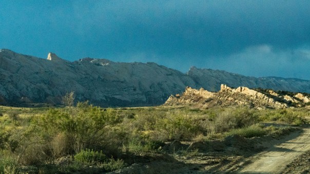
As if that were not enough drama, deep below these layers, accumulating under water, were vertical faults caused by various compressional forces. Above the faults, the layers were vertically displaced. In the Waterpocket Fold’s case, this movement along the fault caused the west side to shift upwards by more than 7.000 feet compared to the the east side. The overlying sedimentary layers were draped above the fault and formed a monocline.
We drove north from Bullfrog along a long cliff formed by this monocline and then turned west to go through it on our way to Boulder, Utah.
I can’t imagine any place more different from Utah than Lithuania, but it sure looks like an interesting place to visit.